SAVE TIME AND INCREASE ACCURACY

Welcome to the world of surveying 2.0 and BIM

Mission

Bridging the gap between geomatics and surveying as well as the planning and construction professions in an increasingly digitized world

Commited experts for your projects
H4G is a multidisciplinary firm made up of experienced collaborators specialized in surveying, architecture, geomatics, urban planning and engineering.We are the reference in the digitization and management of geospatial data for AEC development professionals whether it is for the redevelopment of a building or the development of a land

ABOUT

Get scans in 3 times less acquisition time than traditional tools. We accurately digitize buildings, structures and land topography.

OUR EXPERTISE

We provide our BIM expertise in geomatics, surveying and architecture at your service to help you carry out your projects and maximize your success. We are available and committed for any support in these fields.

OUR CUTTING-EDGE PROCESSES

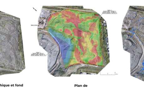
H4G geomatics works with professional drones designed for commercial and industrial applications. We have an advanced pilot certificate, a permanent permission issued by Transport Canada, to fly on most of the Canadian territory.

h4geo services

We offer a range of services to optimize and facilitate your projects
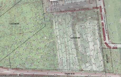
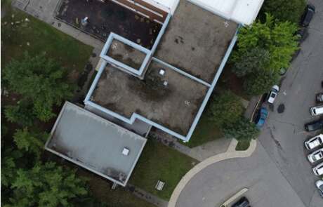
Scan to BIM -
ARCHITECTURE

This service will allow you to know all the variations and changes of an existing building through time and renovations in order to generate "as-is" plans.

Find out more –>

Scan to BIM -
Structure

LiDAR scanning can help identify problems caused in existing buildings, such as cracks, deviations and deformations. By identifying these issues at an early stage, engineers can take corrective action before serious damage occurs.

Find out more –>

Scan to BIM -
MEP

With BIM laser scanning, MEP engineers can obtain a highly accurate 3D model of MEP systems. This information can assist in the design and planning of new MEP systems, as well as the renovation or upgrade of the existing systems.

Find out more –>

Deflection and
slopes studies

Deflection study with laser scan is a technique used to analyze the deformation or deflection of an object or structure under various loads or stresses.

Find out more –>

Thermography

Thermography is a non-invasive diagnostic technique that uses infrared imaging used to identify areas of heat loss or gain, which can help identify potential problems with insulation, air leaks, or moisture intrusion.

Find out more –>

Topographic Lidar

Topographic LiDAR is a remote sensing technology that uses a laser scanner to quickly obtain fine and precise topography, even under dense canopy. From this raw data we can produce digital terrain models (DTM), contour lines, slope studies and other derived products.

Find out more –>

Photogrammetry

Photogrammetry is the science of obtaining reliable 3D measurements and data about objects, structures, and environments using photographs and stereoscopy. Drone photogrammetry has several unique advantages for environment, urban planning and architecture.

Find out more –>

Contact-us and get an offer in 24h

Portfolio

Discover H4GEO projects

Dona G.
Great service. Jonathan and his team delivered the results I needed, even with the tight deadlines I gave them (sorry again about that guys). I highly recommend H4G!
Danny Houle
Jonathan est toujours disponible et agile dans la réalisation des projets que nous lui confions!
Arnaud Joakim
The whole team at H4G is very knowledgeable! Make sure you reserve your scan / survey as soon as possible as they are very busy. Their Digital Twin services are very impressive! Looking forward to working again with Jonathan in the near future!
Sam H
Very good service. The survey was was well produced with a quick delivery.
Louis .Pelletier
I was very pleased by the level of expertise of the people at H4G. They delivered on time and did an outstanding job on our data acquisition and digital mapping project in the real estate sector. I highly recommend.
Marc-andre Fustier
Jonathan and his team were very helpful and informative throughtout the whole process of our project. I highly recommend H4G. They delivered on everything promised even with our very short time frame.
Ameur Manceur
Service complet et orienté solution! Utilisation judicieuse des nouvelles approches. Merci! Comprehensive service, solution oriented! Sound use of new technologies. Thanks!
Patricia Guardado
Jonathan et son équipe offrent un service de qualité. Autant pour les rendus numériques et ses autres services. Une équipe rapide et efficace.
Dave Parent
Super service!!
Passeport Urbain
Best service for scan to Revit, very efficient

They trust
us